 To be sure, SMC is not saying that Iran isn't fiddling about with uranium. What we are saying is that the purported immediacy of the Iranian nuclear threat is a flat out fabrication and is wholly related to deep agendas kept well insulated from public consumption and consideration.
That Iran is pursuing ambitious nuclear development is one thing. That Iran in any way, shape or form poses anything resembling a looming military threat is quite another. But be certain, you will be told that one is for all intents and purposes tantamount to the other. Well isn't that special!
Just a few days ago the ISIS (Institute for Science and International Security) presented satellite imagery purchased from Digital Globe's satellite of Iran's nuclear processing plants at Natanz and Ishafan.

ISIS provided a detailed image analysis of what was captured on the commissioned imagery and what would logically comprise the main targets for an attack on Iran should we now choose to take Bush et al at their word of only wanting to knock out a purported nuclear weapons program but months from spewing out WMDs.
Below is an excellent post by a Swedish blogger who acquired older Google Earth satellite imagery of the same processing plants and compared them to ISIS's fresh imagery, demonstrating remarkable developments over the intervening time span.
But again, that developments are taking place is one thing. That developments are taking place that are putting the U.S. in any kind of nuclear peril is quite another. But
 we will not be told this by the Bush Administration. Instead, the ongoing psy-op targeting the American populace will continue to unfold according to script and guilefully exploit any inherently ambiguous events as prejudiced certainties to further their tendencious designs for the region at large. A deep agenda is at work and everything is now vulnerable to duplictous exploitation to further its progress.
...and now onto the referenced blog post:
Via a Reuters report today, the Institute for Science and International Security (ISIS) has released new commercial imagery of Iran's nuclear enrichment facilities taken by DigitalGlobe just a few weeks ago. The images are in a PDF report by Paul Brannan and David Albright, the latter an ex-UN arms inspector and nuclear proliferation expert. (ISIS, whose motto is "Employing science in the pursuit of international peace" has impeccable non-partisan credentials.)
The PDF is fascinating, but the main images lack easy
historical comparisons. Luckily, Google Earth already has very high resolution imagery of both the Natanz and Isfahan sites from a few years ago, also taken by DigitalGlobe. What I've done is repurpose the images from the PDF, which are annotated, as overlays on Google Earth, so that we can see the progress in the construction at both sites over the past few years.
Here is the KMZ file.
The best way to compare Google Earth's base imagery with the overlays is to play with the transparency slider at the bottom of the Places panel.
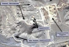
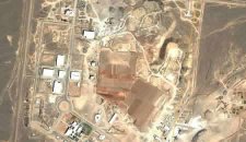
There are two sites covered. Isfahan is where uranium is first processed and where a storage facility is being built underneath a mountain. Here is what it looks like in Google Earth, from a few years ago:
And as of March 23, 2006, courtesy of ISIS and DigitalGlobe:
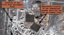
Once the uranium is processed into UF6, it is ready to be enriched at Natanz, 130km to the north. Here, two "cascade halls" have been progressively buried under successive layers of concrete and earth. These facilities are where the thousands of centrifuges are expected to be located that will increase the concentration of the uranium-235 isotope, which is the component needed for both nuclear energy and nuclear bombs. (A concentration of 3.5% is sufficient for nuclear energy. 80% is required for a nuclear bomb.)
Here are the facilities in Google Earth, from a few years ago:
And here they are, on February 25, 2006:
ISIS's PDF report also shows smaller images of these halls being covered up progressively over the past few years.
Both these sites will be military targets if diplomacy fails to steer Iran away from its nuclear weapons program — either for US missiles or, failing that, Israeli planes. The spectre raised by the Seymour Hersh article in last week's issue of the New Yorker is that the US may be thinking of using tactical nuclear weapons to get to the facilities.
Some honest questions, then: Couldn't the underground facilities at Isfahan be rendered inoperable by three deftly aimed conventional missiles at each of the tunnels? So what if the stuff inside is intact, if nobody can get to it? And as for the 8 meters of rubble and concrete over the centrifuge halls in Natanz (as reported by ISIS) — it looks like conventional weapons can easily deal with that: The US military's GBU-28 deep penetration bunker buster bomb is
advertised as being able to penetrate such depths. There is therefore no need to progress to depleted uranium bombs or tactical nukes. In any case, centrifuges are very fragile; shake them up too much and you can start over.
So, thank you ISIS and Google Earth for providing the transparency that lets the public ask informed questions that governments now need to answer if they want their version of events to be credible.


No comments:
Post a Comment